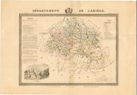
Département de L'Ariége


Section: Maps, plans and nautical charts
Uniform title: ARIEGE (Francia) (Pirineos Meridionales). Mapas generales. 1845-1855. 1:270000 (1844)
Title: Département de L'Ariége / Dressé par A. Donnet ingenieur Géographe ; Gravé par Malo et Bénard
Material or type of resouce Area: [Ca. 1:180000]
Publication: Paris : Dusillion Editeur A Paris, Rue Laffitte, N 40, [1845-1855]
Physical description: 1 mapa : col. ; 47 x 65,3 cm en h. de 62 x 89,5 cm
Notes: Escala gráfica ademas de 5 leguas de posta de 28 1/2 al grado [= 10,1 cm] y 5 leguas comunes de 25 al grado [= 9 cm]. Coordenadas referidas al meridiano de París (E 0°00'-E 2°00'/N 43°24'-N 42°18'). Red geográfica de 5' en 5'
Tabla de signos convencionales para indicar divisiones administrativas, redes de transporte, etc
Leyenda explicativa sobre comunicaciones, recursos, monumentos, hombres famosos del Departamento y distritos en que se divide con datos estadísticos
En el margen inferior notas sobre la autorización que hizo el consejo Real de Instruccion pública del mapa y que fue recomendado a los rectores de Universidad. El atlas fue adoptado por escuelas primarias y superiores y por la Universidad como libro de texto
Inserta: Vue de Foix
En el margen superior escudo con leyenda "armes de Foix"
FRN
En: Atlas des Departemens de la France. Région du Sud Ouest. N. 8
Materia / lugar / evento: Mapas generales
Divisiones administrativas
Correos
Organización territorial militar
Siglo XIX
Pirineos Meridionales (Francia)
Francia
UDC: 912:[71.355.47]:383(44-328 Ariége)'1844'
44-328 Ariége
Type of publication:
 Maps
Maps
Rights:
Préstamo:
 Disponible
