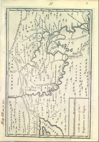
Mesopotamia and Babylonia : with the course of the...


 Maps, plans and nautical charts
Mesopotamia and Babylonia : with the course of the Euphrates and Tigris
Maps, plans and nautical charts
Mesopotamia and Babylonia : with the course of the Euphrates and Tigris
Section: Maps, plans and nautical charts
Uniform title: Mesopotamia. Mapas generales. 1700-1812
Title: Mesopotamia and Babylonia : with the course of the Euphrates and Tigris
Material or type of resouce Area: Escala indeterminada
Physical description: 1 mapa ; 35 x 24 cm
Content type: Imagen cartográfica
Media type: computadora
Carrier type: recurso en línea
Notes: Orientado
Longitud graduada
Red hidrográfica destacada
Relieve por montes de perfil y sombreado
Ciudades representadas por pequeñas edificaciones según su importancia
Toponimia de las regiones, algunos nombres de ciudades, montañas, lagos y ríos
En el águlo superior izquierdo: "Nº 15. Vol. IV. p. 332"
Copia digital. Madrid : Ministerio de Cultura, 2010
Other titles: En: [The maps and plans of the Universal History]. - [Lugar de publicación no identificado] : [Editor no identificado], [1700-1812?]. - [Mapa 8]
Materia / lugar / evento: Geografía bíblica
Mapas históricos
Geografía histórica
Historia
Accidentes geográficos
Ríos
Eúfrates (Río)
Tigris (Río)
Oriente Medio
Related titles: Babilonia (Ciudad desaparecida). Mapas generales. 1700-1812
UDC: 5-011
Type of publication:
Maps
Rights:
