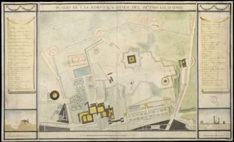
Plano de las fortificaciones del Retiro en Madrid


 Disponible Holdings
 Section: Maps, plans and nautical charts
Uniform title: Madrid. Distrito de Retiro. Fortificaciones. 1820. Ca. 1:3.300
Title: Plano de las fortificaciones del Retiro en Madrid
Material or type of resouce Area: Escala [ca. 1:3.300]. 2.000 pies castellanos [=16,7 cm]
Publication: [1813?]
Physical description: 1 plano : ms., col., montado sobre tela ; 59,7 x 98,4 cm
Content type: Imagen cartográfica
Media type: computadora
Carrier type: recurso en línea
Notes: Manuscrito coloreado a la acuarela en verde, amarillo y gris
Relieve representado por sombreado
Relación de las baterías, baluartes y otros edificios y lugares significativos de la zona indicada por clave numérica inscrita en lienzo y decorada con guirnaldas
Incluye: "Seccion de la Bateria y Plataforma de la Artilleria" ; "Seccion de la Bateria y Puente lebadizo, garita y Centinela". Escala [ca. 1:320]. 100 pies castellanos [= 8,6 cm]
Sello del Estado Mayor General del Ejército
Materia / lugar / evento: Fortificaciones
Planos de población
Parques públicos
Guerras de independencia
Madrid
España
España - Historia - 1808-1814 (Guerra de la Independencia)
Genre / form: Manuscritos
UDC: 912:623.1+[314(084.3)](460.27-2)"1820"
460.27-2
Type of publication:
 Maps
Maps
Rights:
Préstamo:
Disponible
