Map of Bowling Green, Ky., showing its approaches and...


 Maps, plans and nautical charts
Map of Bowling Green, Ky., showing its approaches and defenses (189-?)
Maps, plans and nautical charts
Map of Bowling Green, Ky., showing its approaches and defenses (189-?)
 Disponible Holdings
 Section: Maps, plans and nautical charts
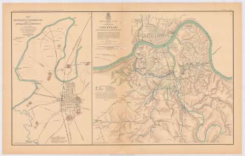
Title: Map of Bowling Green, Ky., showing its approaches and defenses / surveyed and drawn under authority of Maj. J.H. Simpson, Chief Engr. Department of the Ohio, by Lieut. N.S. Andrews, 6th. Mich. Battery, acting Engineer, 1863 ; Office, U.S. Engineers, Cincinnati, O.
Material or type of resouce Area: Escala [ca. 1:21180], mile [= 3,6 cm]
Publication: Washington : Government Printing Office, [189-?] (N.Y. [Nueva York] : Julius Bien & co.)
Physical description: 1 mapa : col. ; 42x26 cm, en h. de 47x75 cm
Content type: Imagen cartográfica
Media type: computadora
Carrier type: recurso en línea
Notes: En : Atlas to accompany the Official Records of the Union and Confederate Armies 1861-1865. - Plate CIII, n 1
Relieve : líneas perpendiculares normales
Mapa que acompaña al informe del 'J.H. Simpson'
Figura en margen inferior : Series 1. Vol XXXIX. Part 2. Page 769
Representadas mediante color azul las posiciones del ejército de la Unión
Figura nota de las fortificaciones
Figura rúbrica impresa
En : Atlas to accompany the Official Records of the Union and Confederate Armies 1861-1865
Materia / lugar / evento: Guerra civil
Fortificaciones
Fortalezas militares
Redes de transporte
Planos de población
1863
Estados Unidos
UDC: 912:355.4]:[623.2+623.1](769 Kentuchy)'1863'
912:314(769 Kentuchy) (084.3)
769 Kentuchy
Type of publication:
Maps
Rights:
Préstamo:
Disponible
