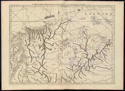
The Coast of Tierra Firma : from Cartagena to Golfo Triste
Section: Maps, plans and nautical charts
Uniform title: COLOMBIA. N. Cartas náuticas. 1:1500000 (1775)
Title: The Coast of Tierra Firma : from Cartagena to Golfo Triste [Mapa] / By Thomas Jefferys, Geographer to His Majesty
Material or type of resouce Area: Escala [ca. 1:1500000 ; proy. Mercator]
Publication: London : Printed for Robt. Sayer, Map and Printseller, N°. 53 in Fleet Street, 1775
Physical description: 1 map. ; 45 x 61 cm
Notes: En : "The West Indian Atlas". Map 16
Carta arrumbada, orientada con lis
Escala gráfica de 20 leguas marinas de 20 al grado [= 7'3 cm]. Coordenadas referidas al meridiano de Ferro (O 58°00'--O 49°30'/N 13°10'--N 7°00') y de Londres (O 75°35'--O 67°5'/N 13°10'--N 7°00'). Red geográfica de 1° en 1°
Orografía de perfil. Sondas batimétricas
Señala bancos de arena, la línea de derrota entre España y Cartagena de Indias, bajos, fondeaderos, ríos, poblaciones y caminos
Decorado con figuras de embarcaciones
Other authors: Jefferys, Thomas, ca. 1710-1771
Sayer, Robert, 1725-1794
Related titles: Título: The West Indian Atlas
UDC: 912:551.46]:527.6(861-17)"1775"
861-17
87-16
Type of publication:
![]() Articles and chapters
Articles and chapters


