Chart of part of the Bahama Islands showing the tracks...


 Maps, plans and nautical charts
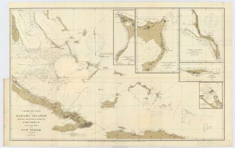
Chart of part of the Bahama Islands showing the tracks ascribed to Columbus on his descovery of the New World (April 1881)
Maps, plans and nautical charts
Chart of part of the Bahama Islands showing the tracks ascribed to Columbus on his descovery of the New World (April 1881)
 Disponible Holdings
 Section: Maps, plans and nautical charts
Uniform title: BAHAMAS. Cartas náuticas. 1881 (1492-1502). 1:1133786
Title: Chart of part of the Bahama Islands showing the tracks ascribed to Columbus on his descovery of the New World / Compiled and drawn, under the direction of W.T. Bright, In charge of Drawing Division, by T.J. O'Sullivan draughtsman
Material or type of resouce Area: Escala [ca. 1:1134786] (O 77°50'-O 68°10'/N 24°55'-N 19°10')
Publication: [Washington] : U.S. Coast and Geodetic Survey Office, April 1881
Physical description: 1 carta náutica ; 56 x 91 cm
Content type: Imagen cartográfica
Media type: computadora
Carrier type: recurso en línea
Notes: Escala hallada a partir de 1° de latitud [= 9'8 cm]. Orientado con gráfico de declinación magnética
Relieve por normales y puntos acotados
Indica sondas batimétricas, así como la línea de derrota seguida por Cristóbal Colón
Inserta: "Crooked islands" ; "Acklins island" ; "Lang island" ; "Samana or At wood Cay" ; "Clarence Harbour"
Materia / lugar / evento: Cartas náuticas
Batimetría
Islas
Cayos
Derroteros
1881
Cuba
República Dominicana
Haití
Crooked
Acklins
Isla Larga
Clarence Town
Cayo Samaná (Isla)
Other authors: Bright, W. J
O'Sullivan, T. J
Estados Unidos. Coast and Geodetic Survey
UDC: (729.61)
Type of publication:
Maps
Rights:
Préstamo:
Disponible
