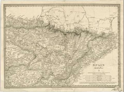
Spain (España) : II


Section: Maps, plans and nautical charts
Uniform title: ESPAÑA. NE. Mapas generales. 1:1800000 (1831)
Title: Spain (España) : II / Published under the Superintendence of the Society for the Diffusion of Useful Knowledge ; J.&.C. Walker sculpt
Material or type of resouce Area: Escala [ca. 1:1800000 ; proy. cónica] (E 3°50'00''--O 3°35'00''/N 43°45'00''--N 40°45'00'')
Publication: [London] : Published by Baldwin & Gradock 47 Paternoster Rouu, June 1st. 1831
Physical description: 1 mapa : montado sobre tela ; 24 x 33 cm
Content type: Imagen cartográfica
Media type: computadora
Carrier type: recurso en línea
Notes: Comprende las regiones de Cataluña, Aragón, Navarra, Vascongadas, noroeste de Castilla la Nueva y este de Castilla la Vieja
Escalas gráficas de 16 1/4 leguas españolas, 26 1/2 leguas castellanas, 18 leguas portuguesas, 25 leguas francesas de postas y 69 millas británicas [= 6,2 cm]
Relieve por normales y puntos acotados, expresados en yardas
Materia / lugar / evento: Mapas generales
Other authors: Society for the Diffusion of Useful Knowledge (Gran Bretaña)
J. & C. Walker
Baldwin & Cradock (Londres)
UDC: 912(460-18)"1831"
460-18
Type of publication:
 Maps
Maps
Rights:
Préstamo:
 Disponible
