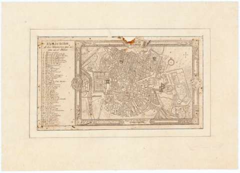
Plano de Madrid


Section: Maps, plans and nautical charts
Uniform title: Madrid. Planos de población. 1762. Ca. 1:32.400
Title: Plano de Madrid / Laurentius â Mansilla fec
Material or type of resouce Area: Escala [ca. 1:32400]. 600 varas castellanas [= 1,6 cm]
Publication: [Madrid? : [Editor no identificado], 1762?]
Physical description: 1 mapa : montado sobre tela ; 11 x 20 cm en hoja de 18 x 26 cm
Content type: Imagen cartográfica
Media type: computadora
Carrier type: recurso en línea
Notes: En el verso: "Es copia del plano reducido por D. Ventura Rodriguez Grabado y adornado por Tomás Lopez, en el año 1759 que sirvio para ilustrar algunas de las ediciones del "Kalendario manual y Guia de Forasteros de Madrid"
La escala corresponde a 900 varas castellanas por pulgada. Orientado con flecha
Relación de las plazas, calles y edificios más notables de la ciudad indicados por clave numérica
Enmarcado en orla en la que figuran los escudos de España y de la ciudad de Madrid
Procede de la "Colección Rico y Sinobas"
Materia / lugar / evento: Planos de población
Madrid
Other authors: Mansilla, Lorenzo
UDC: 912:[314(084.3)](460.27-2)"1762"
460.27-2
Type of publication:
 Maps
Maps
Rights:
Préstamo:
 Disponible
