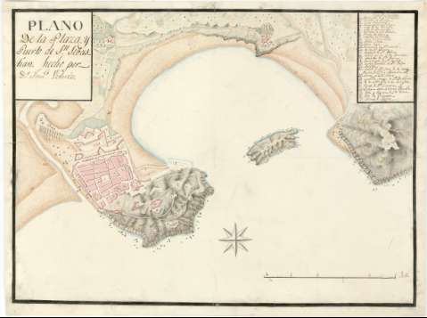
Plano de la Plaza y Puerto de Sn. Sebastian


Section: Maps, plans and nautical charts
Uniform title: SAN SEBASTIÁN (Guipúzcoa). Planos de población. 1:28.800 (1750)
Title: Plano de la Plaza y Puerto de Sn. Sebastian / hecho por Dn. Franco. Urtariz
Material or type of resouce Area: Escala [ca. 1:28800]
Physical description: 1 plan. : ms., col., montado sobre tela ; 45,8 x 61,2 cm
Content type: Imagen cartográfica
Media type: computadora
Carrier type: recurso en línea
Notes: Fecha tomada del catálogo del SGE: "Región Vasco-Navarra. Provincia de Guipúzcoa. Siglos XVI a XIX". 1969, p. 190
Escala gráfica de media milla [= 19,3 cm]. Orientado con rosa de ocho vientos
Orografía por sombreado y por el dibujo convencional de la forma del roquedo
Relación de las principales fortificaciones (castillo de Santa Cruz, baluartes, etc), plazas y edificios más destacados de la ciudad (conventos, colegios, ermitas, etc.), indicados por clave numérica
Materia / lugar / evento: Planos de población
Fortificaciones
1750
Guipúzcoa
País Vasco
Other authors: Urtariz, Francisco
UDC: 912:[314(084.3)]:623.1(466.212-2)"1750"
466.212-2
Type of publication:
 Maps
Maps
Rights:
Préstamo:
 Disponible
