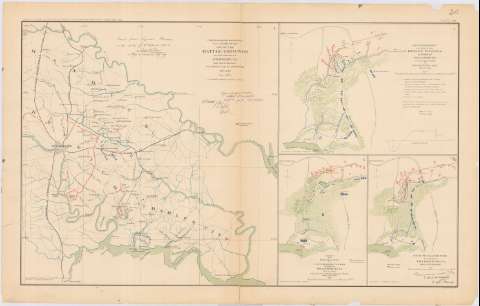
Map of the battle - grounds in the vicinity of Richmond,...
Sección: Mapas, planos y cartas náuticas
Título: Map of the battle - grounds in the vicinity of Richmond, V.A. : 1862 and 3 / Made under the direction of A.H. Campbell, capt. P.E. and Chr. Topr. Dept. ; Chief Engineer Office D.N.V. col. J.F. Gilmer, Chf. Engr.
Área de datos: Escala 1:240000
Publicación: Washington : Government Printing Office, [189-?] (N.Y. [Nueva York] : Julius Bien & co.)
Descripción física: 1 mapa : col. ; 41x41 cm, en h. de 47x75 cm
Tipo de contenido: Imagen cartográfica
Imagen cartográfica
Tipo de medio: computadora
computadora
Tipo de soporte: recurso en línea
recurso en línea
Notas: En : Atlas to accompany the Officials Records of the Union and Confederate Armies 1861 - 1865. - Plate XX, n 1
Coordenadas : O77 30'-O76 40'/N37 50H-N37 12'. Meridiano de Washington ?
Mapa que acompaña al informe delGen. R.E. Lee
Figura texto y rubrica impresa
Figura en margen inferior : Series 1. Vol. XI. Part 2. Page 500
En : Atlas to accompany the Official Records of the Union and Confederate Armies 1861 - 1865
Materia / lugar / evento: Guerra civil
Batallas
Fortificaciones
Baterías
1892
Estados Unidos
Otros autores: Campbell, A. H. (Albert H.)
CDU: 912:355.4]:[355.422+623.2+623.1](755 Richmond)'1862'
755 Richmond
Tipo de publicación:
![]() Mapas
Mapas
Préstamo:
![]() Disponible
Disponible


