Kort over Siaelland og Moen med tilgraendsende Kystey af...


 Mapas, planos y cartas náuticas
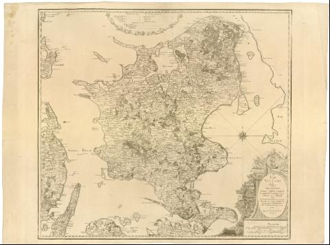
Kort over Siaelland og Moen med tilgraendsende Kystey af Skaane Falster Laaland Langeland Thorsinge Fyen Samsoe og... (1777)
Mapas, planos y cartas náuticas
Kort over Siaelland og Moen med tilgraendsende Kystey af Skaane Falster Laaland Langeland Thorsinge Fyen Samsoe og... (1777)
 Disponible Ejemplares
 Sección: Mapas, planos y cartas náuticas
Título uniforme: SELANDIA (Dinamarca) (Isla). Mapas generales. 1:250000 (1777)
Título: Kort over Siaelland og Moen med tilgraendsende Kystey af Skaane Falster Laaland Langeland Thorsinge Fyen Samsoe og Jylland / under det Kongl. Viidenskabernes Societets Direction ved sigtig Landmaaling optaget og ved trigonometriske samt astronomiske Operationer provet ; tegnet of C. Wessel og H. Skanke ; Guiter sculpsit
Área de datos: Escala [ca. 1:250000], 3 geographis. Ke Mul [= 9 cm]
Publicación: [Kobenhaun ? (Copenhague) : Kongl. Viidenskabernes Societets Direction], 1777
Descripción física: 1 mapa ; 61x67 cm en h. de 64x85 cm
Notas: Escalas gráficas de 3 almindelige Danske Mul [= 9 cm], 1200 Alen [= 9 cm]. Coordenadas referidas al meridiano de Copenhague (O2#00'-E0#28'/N56#08'-N54#52'). Red geográfica de 5' en 5'. Orientado con lis en rosa de 16 vientos
Relieve representado por normales
Tabla de signos convencionales para indicar núcleos de población de distinta categoria, caminos y límites administrativos
Indica masas forestales
Título enmarcado en cartela arquitectónica con fauna, flora, estandarles y un blasón de tres leones
Materia / lugar / evento: Mapas generales
1777
Selandia (Isla)
Laaland (Isla)
Otros autores: Wessel, Caspar, 1745-1818
Skanke, H
Guiter, Ch. A
CDU: 912(489 Selandia, isla)'1777'
(489-328 Lolland Falster)
Tipo de publicación:
Mapas
Derechos:
Préstamo:
Disponible
