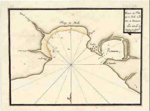
Plano de playa de Miel y Puerto de Baracoa


 Disponible Holdings
 Section: Maps, plans and nautical charts
Title: Plano de playa de Miel y Puerto de Baracoa
Material or type of resouce Area: Escala indeterminada
Publication: [1776?]
Physical description: 1 carta náutica : ms., col., montado sobre tela ; 23,6 x 32 cm
Content type: Imagen cartográfica
Media type: computadora
Carrier type: recurso en línea
Notes: Orientado con media lis en nudo de 16 rumbos
Indica fondeaderos, calidad del fondo y sondas batimétricas
Fecha de ejecución tomada del: "Catálogo de Mapas y Planos. Cuba", del Servicio Geográfico del Ejército. 1974
Manuscrito coloreado a la acuarela en varios colores
En el ángulo superior derecho, nota en la que se indica que los números de las sondas son brazas. Debajo: "constan las letras J.J.B."
Reproducción digital. Centro Geográfico del Ejército, 2009
Materia / lugar / evento: Cartas náuticas
Bahías
Playas
Puertos
Fondeaderos
Batimetría
Siglo XVIII
Baracoa
Oriente (Cuba)
UDC: 729.16 Miel
Type of publication:
 Maps
Maps
Rights:
Préstamo:
Disponible
